about US
Our Mission
- Protecting wildlife connections
- Conducting habitat restoration projects
- Protecting wetlands and streams
- Engaging volunteers and stakeholders in projects, mapping, and advocacy.
Wild Connections protects and restores wild nature and public lands across the watersheds of the Arkansas and South Platte Rivers in central Colorado. We recognize these as the ancestral lands of the Ute, Cheyenne, Arapaho and other indigenous peoples.
Connecting Wildernesses and roadless areas in a landscape-wide wildlands network across the central Rockies benefits migratory animals, rare plant communities, clean water resources for urban and mountain communities, local economies, quiet recreation, historic and cultural locations, scenic vistas and spirtual values.
Connecting Wildernesses and roadless areas in a landscape-wide wildlands network across the central Rockies benefits migratory animals, rare plant communities, clean water resources for urban and mountain communities, local economies, quiet recreation, historic and cultural locations, scenic vistas and spirtual values.
Where we work

Map Alison Gallensky, Wild Connections
Wild Connections focuses primarily on Colorado federal and state public lands south and east of the Continental Divide and west of the I-25 corridor.
The Pike-San Isabel National Forest and the Bureau of Land Management Royal Gorge Field Office together administer 2,780,000 acres of federal lands here.
In addition, the National Park Service oversees Browns Canyon National Monument and Florissant Fossil Beds National Monument.
State Wildlife Areas, State Parks and County Open Spaces also provide for wildlife and recreation.
Wild Connections 2024 Annual Report
We're excited to announce that our Annual Report for 2024 is now available! Take a deep dive into our achievements, growth milestones, and strategic initiatives from the past year. The report includes detailed financial performance, key project highlights, and our vision for the future.
- Click on the image above to view or download our report.
What we've Accomplished
.jpg)
Map Alison Gallensky, Wild Connections Download PDF version.
- Wild Connections Conservation Plan (WCCP) 1995-2006
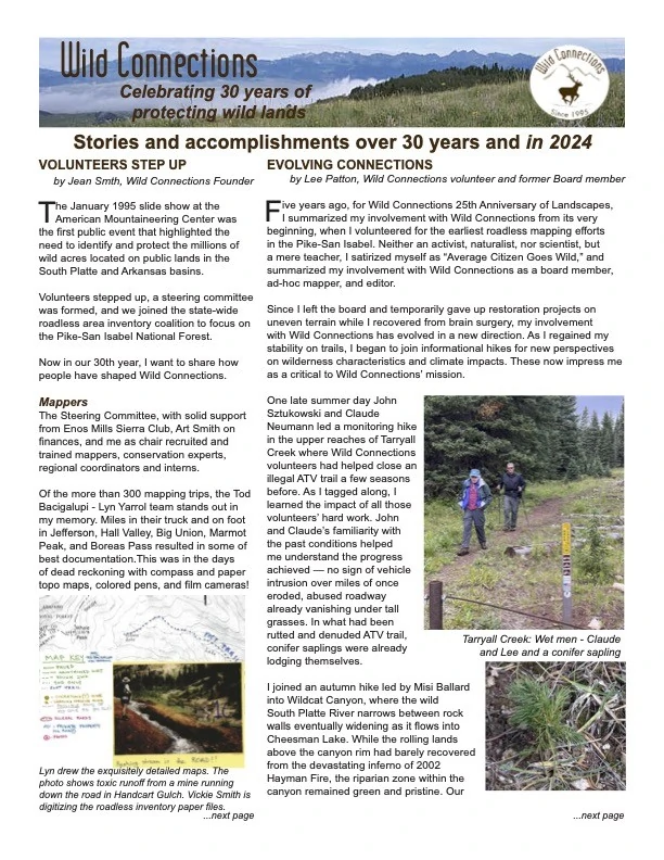
- Roadless Area Inventories by more than 100 volunteer mappers identified 1.2 million acres of wild roadless land on the Pike-San Isabel National Forest from 1995 to 2001.
- The WCCP published in 2006 was based on the roadless data, input from 7 regional workshops and wildlife data
- The WCCP proposes Wilderness( 684,400 acres), Research Natural Areas (179,6000 acres) and Core Areas (94,700 acres ) for the network of wildlands across the region
- Colorado Roadless Rule 2008-2012
- The Forest Service reviewed Wild Connections’ inventory and added 107,400 acres to their inventory as part of defining the 2012 Colorado Roadless Rule.
- Roadless lands protected in the Pike-San Isabel National Forest increased more than 16% as a result.
- Lands with Wilderness Characteristics Inventory 2013–2015
- Staff, interns and volunteers mapped and documented Lands with Wilderness Characteristics on the lands administered by the Bureau of Land Management from 2013 to 2015.
- The BLM reviewed Wild Connections’ inventory and added 113,000 acres to their inventory as part of the agency’s Resource Management Plan revision.
- Lands with Wilderness Characteristics identified in the BLM's Royal Gorge Field Office increased by more than 145% as a result.
- Restoration Projects 2009 - ongoing
- Wild Connections’ restoration projects have been completed or are ongoing:
- Puma Hills 2024-2025
- Wildcat Canyon 2016-2025
- Rock Creek 2018-ongoing
- LaSalle Pass 2020
- Beaver Creek 2019-2020
- Sheep Creek 2019
- Selkirk Basin, N. Tarryall 2016, 2018
- Farnum Peak, Packer Gulch 2015, 2017
- Badger Flats 2014
- Geneva Creek 2013
- Green Mountain 2011
- Trout and Eagle Creeks 2009-2010
- Conservation Vision and Biodiversity Research
- Climate Change Refugia modeling is ready for expert review.(2019-ongoing)
- Volunteers help with the Pawnee montane skipper butterfly census conducted annually by the Forest Service and the Fish and Wildlife Service.
- Advocacy and Outreach
- We chair the regional coalition addressing BLM management planning and mining and energy projects in the Arkansas Canyon
- Regular comments and public organizing on agency activities includes the Pike-San Isabel Travel Management Plan, Outside 285 regional trail planning, and many logging, mining and energy development projects.
- We continue to promote Wilderness, including the designation of Browns Canyon National Monument and impending legislation in the Colorado Wilderness Act and Protecting America’s Wilderness Act.
- We represented conservation interests during the multi-year process that resulted in the South Platte River Protection Plan that was adopted in lieu of Wild and Scenic River designation
- The public is engaged and informed through monthly guided roadless area hikes, press releases and opinion editorials, and regular Wild News and Landscapes newsletters